ArcGIS Mission

Mission management software that combines situational awareness with command and control

Contact sales
Collage of drone imagery of green land and buildings, 2D digital map of a city, and people working on computers and tablets

A geographic approach to command and control

ArcGIS Mission is an all-inclusive command and control system for tactical operations powered by ArcGIS. ArcGIS Mission fuses your organization’s data in ArcGIS Enterprise with real-time updates from the field and the command center to streamline mission management and inform decision-making. Use one solution to plan, execute, and review operations and respond to unplanned incidents.

Utilize critical incident mapping tools to define areas of interest (AOI) and map tactical resource assignments. Coordinate team movements with real-time situational awareness and updates via persistent communication. Perform an after-action review to discover patterns and improve future operations with key mission data that is securely stored in your ArcGIS Enterprise portal.

Download a PDF of this page

Watch ArcGIS Mission in action

See how ArcGIS Mission can provide one common operating picture for team situational awareness.
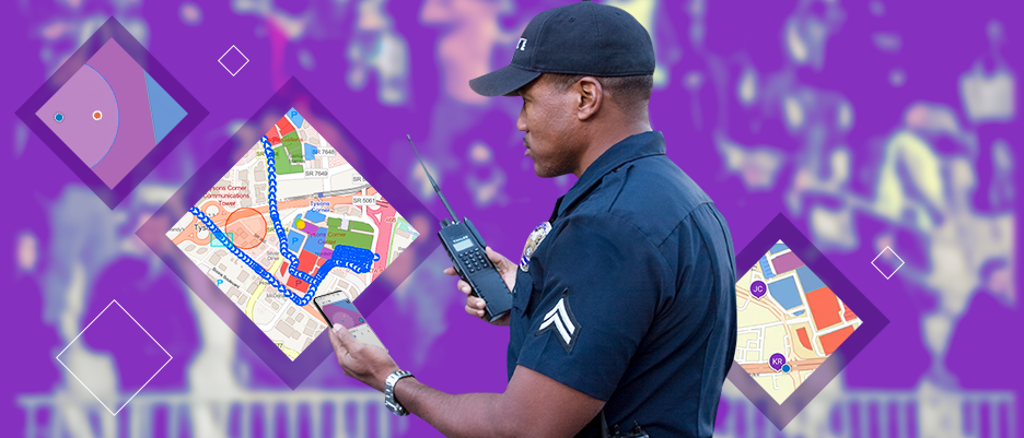
Police officer in a blue uniform holding a walkie-talkie and using a map app on a cell phone with an inset digital map image

Situational awareness software to plan, execute, and review tactical operations

ArcGIS Mission enables you to streamline workflows, coordinate tactical maneuvers, stay connected with your team, and improve understanding of your operations.

Integrated command and control

Integrate your organization’s geographic information system (GIS) data, authoritative maps, live data streams, and real-time updates from field-based personnel and analysts in command centers for informed decision-making in critical situations.

Person sitting at a desk viewing a 2D gray colored map and text on a computer monitor next to two large computer monitors

Tactical situational awareness

Utilize critical incident mapping tools to visualize where resources and personnel are to coordinate team movement. Update your map in real time based on updates from the field and across command centers.

Man at a desk with a headset looking at two computer monitors that show a 2D digital map and a live video feed

Persistent communication

Stay connected with persistent communication that enables your team to share location details, chat history, tasks, and reports for stronger collaboration.

The hands of a person holding a smart phone displaying a digital street map and a chat window with messages

Improved understanding

Leverage mission data to gain insights through temporal analysis, increase transparency, and build trust with your team through postincident analysis and review.

Man sitting at a desk with two computer monitors that show a 2D map and live video feeds with numerical data and text

Securely store and manage data

ArcGIS Mission is designed to securely store and manage your mission activities inside of ArcGIS Enterprise. Key mission data—such as chat messages, photos, and location tracks—is documented and stored for after-action review and playback.

Man with glasses and a blue coat at a desk reviewing a list of ArcGIS Mission operations on a computer with photos and text

How it works

Plan

Quickly create a mission by selecting an authoritative map from your organization's ArcGIS Enterprise deployment as the foundation to help define areas of interest, assign teams, map your resources, and share critical information.

Red square over an area of interest on a digital map of North America in ArcGIS Mission computer interface

Execute

Integrate and visualize multiple data streams securely in ArcGIS to track, monitor, and coordinate operations from the field and the command center.

The ArcGIS Mission map interface on a mobile device and a computer with text and digital maps with streets and buildings

Review

Conduct temporal analysis on mission activity to evaluate and understand patterns, enhance performance, and improve planning for future missions.

An ArcGIS Mission dashboard interface showing report information with text and numbers with a digital 2D street map

One solution, multiple insights

ArcGIS Mission is a command and control system that integrates critical incident mapping, situational awareness, and mission management via three integrated components.

Previous
Next

Esri Blog

Smart maps and collaboration boost public safety

Alabama Law Enforcement Agency successfully deployed a new GIS command and control security system for the governor’s inauguration.

Read the story

Integrate seamlessly with ArcGIS

ArcGIS Mission provides a common operating picture for your organizations’ critical mission needs, powered by the ArcGIS system. Extend ArcGIS Mission workflow capabilities with products in the ArcGIS ecosystem.

ArcGIS Enterprise

ArcGIS Enterprise

Integrate your organization’s data, live data feeds, and new data from field-based responders in ArcGIS Mission, which is powered by the industry-leading GIS technology in ArcGIS Enterprise.

Explore ArcGIS Enterprise
ArcGIS Excalibur

ArcGIS Excalibur

Use ArcGIS Excalibur to search, analyze, and annotate imagery to share as reports or dynamic layers to enhance situational awareness within ArcGIS Mission.

Explore ArcGIS Excalibur
ArcGIS AllSource

ArcGIS AllSource

ArcGIS AllSource can help you analyze various types of data from multiple sources to uncover patterns, trends, and relationships to inform your operations in ArcGIS Mission.

Explore ArcGIS AllSource
ArcGIS Video Server

ArcGIS Video Server

Index, search, discover, and publish video services with geospatial and temporal context for advanced intelligence analysis.

Explore ArcGIS Video Server

Extended capabilities

Enhance your ArcGIS Mission common operating picture with these extended capabilities.

Previous
Next

Need more information?

Email us

Questions about buying ArcGIS, pricing or need support? Email us at solutions@esribelux.com

solutions@esribelux.com

Contact customer support

Visit our support page

Visit

Call us

Speak with a representative

32 (0)2 460 74 80