Discover the possibilities
ArcGIS Maps for Office allows for the perfect integration between Microsoft Office and ArcGIS software. With this free downloadable add-in, you can view your data in a different perspective. You can instantly add location context to your Excel spreadsheets to get a better overview of the situation. Additionally, ArcGIS Maps for Office allows you to add interactive maps to your PowerPoint presentations to impress your audience.
In order to use ArcGIS Maps for Office, you need both Microsoft Office and an ArcGIS account. ArcGIS Maps for Office works with both ArcGIS Online and ArcGIS Enterprise. All that is needed is to download the installer for this add-in from the website and install it on your computer. Any user will then be able to log in to ArcGIS Maps for Office with their own ArcGIS account when using Microsoft Excel or PowerPoint on their computer.
Add location context to your data in Excel
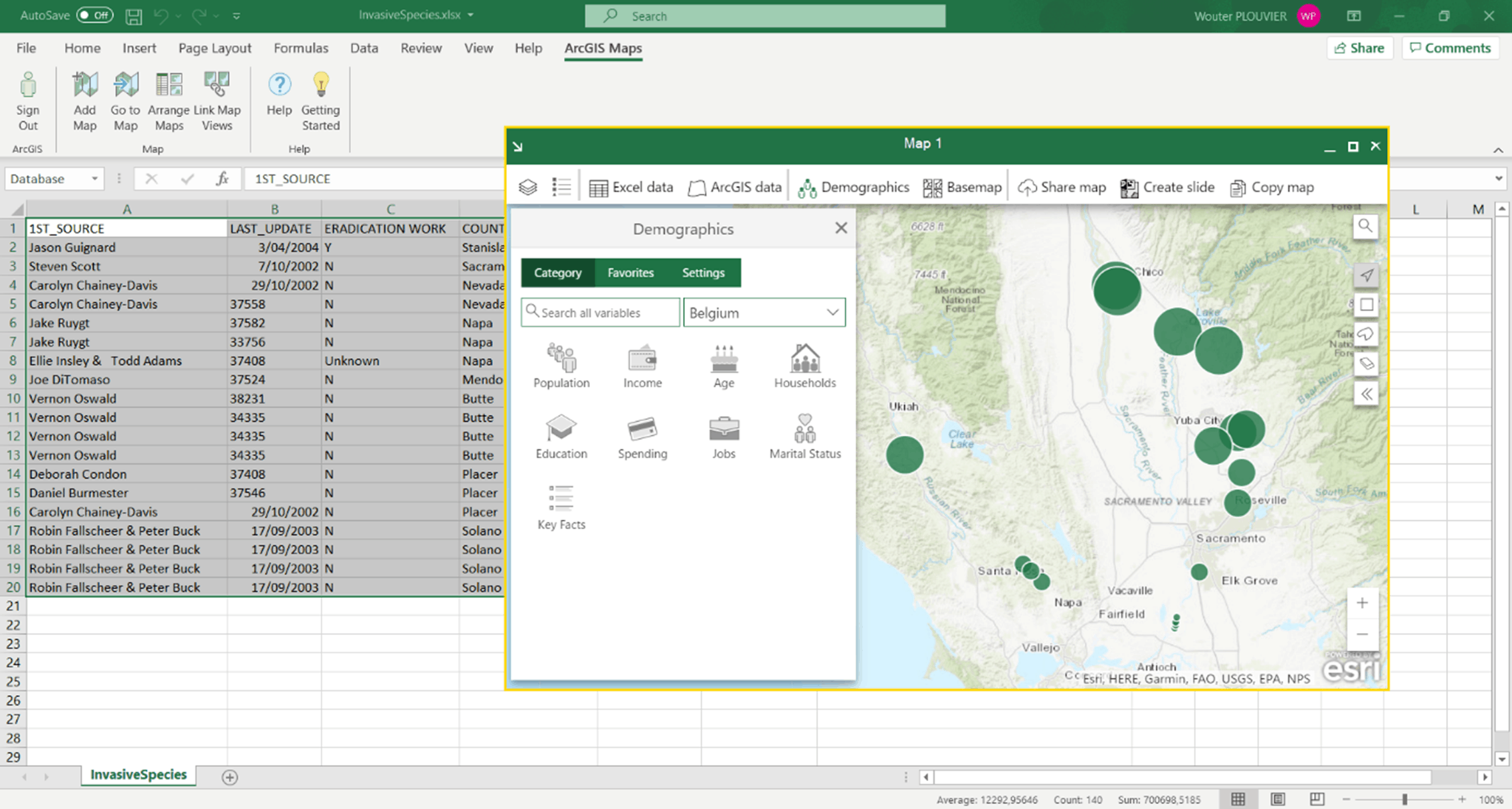
Thanks to the addition of ArcGIS Maps for Office, you can visualise your data directly in Excel. The installation of this program adds an extra tab to Excel called ArcGIS Maps. Here you can log in with your ArcGIS Online/Enterprise login credentials. After logging in, you will also have access to your own ArcGIS data and data from Esri such as the Living Atlas and the base maps.
To add your Excel data, choose the option “Add map” on the added tab ArcGIS Maps. In this map, you can start adding data from your own spreadsheet to give location context to your data. You can then combine your data with your own layers from ArcGIS Online/Enterprise or combine different verified global data layers on demographics, lifestyle, and geography.

You can work with multiple maps simultaneously and arrange or link the map views to get a better overview of multiple data sets. Finally, it is possible to share data directly from Excel as a layer to your ArcGIS Online/Enterprise. You even have the option to choose who you want to share with, so that you can immediately update your colleagues with the latest changes in the data. You can also create an image and add an interactive map directly to your Microsoft PowerPoint presentation.
Add interactive maps to Microsoft PowerPoint
ArcGIS Maps for Office also offers new ArcGIS capabilities for PowerPoint. With interactive maps directly in your slides, you can better inform your audience. Just log in to PowerPoint with your ArcGIS Online/Enterprise account and you have instant access to the range of layers and maps you are used to. You can choose from your own layers, those of your organisation or even layers from the Living Atlas.
Customise your map to your wishes and add it to your slide. During your presentation, you will have your map available, and you can even unlock it to make it interactive. Unlike an image, this map is also linked to the layers on ArcGIS Online/Enterprise, so any changes made there will also become directly visible in the presentation map.

Additional information
Installation program ArcGIS Maps for Office:
Tutorial ArcGIS Maps for Office:
More info installation & use:
- https://doc.arcgis.com/en/maps-for-office/install-and-configure/install-on-a-single-computer.htm
- https://doc.arcgis.com/en/maps-for-office/design-and-use/about-arcgis-maps-for-office.htm
- https://www.youtube.com/watch?v=15hVPQs1WQU
- https://doc.arcgis.com/en/maps-for-office/install-and-configure/configure-esri-maps-for-office.htm
3 ways to contact the Esri BeLux Support Team
Click here to fill in our Support Form

