Discover the possibilities
ArcGIS Field Maps is a mobile application which brings together map viewing, data collection and location tracking. It makes it easier to work in the field and to coordinate with office work. Field workers can use this application with ArcGIS Online or ArcGIS Enterprise starting from version 10.6.1.
Field Maps has a web application as well as a mobile application. The web version allows you to configure maps for the field and the mobile application allows you to view maps online or offline, to collect data and to track user locations.
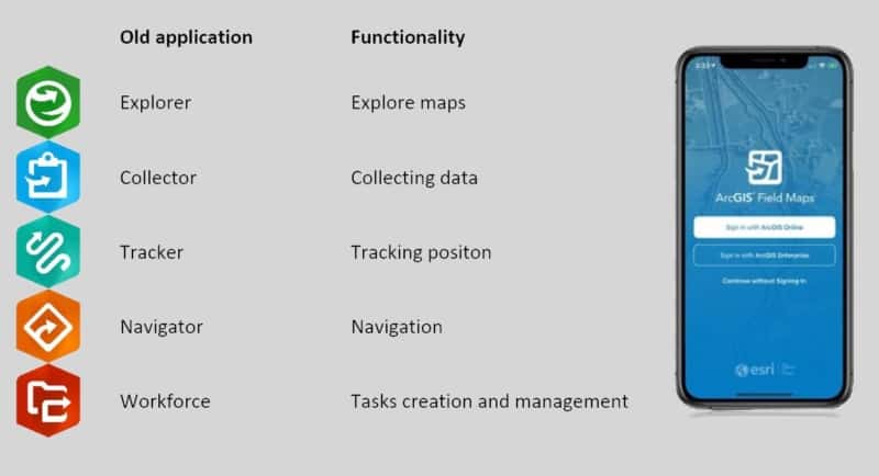
Field Maps is intended to replace 5 separate field applications.
These five applications and their functionalities are as follows.

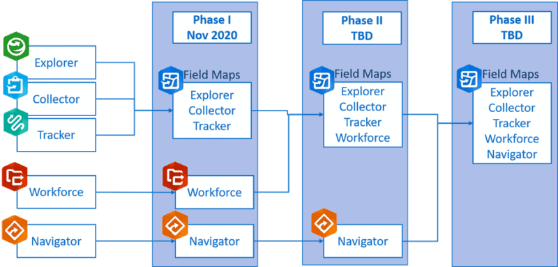
For the time being, Field Maps is in phase 1 of the development, and only Explorer, Collector and Tracker are integrated. In the future, Navigator and Workforce will be integrated, but the exact date is not yet known. Since everything which is possible in the individual apps will also be possible in Field Maps, the three already integrated apps will be deactivated in December 2021.
Timeline

Benefits of Field Maps
- Only one application to download
- One connection to your ArcGIS Online/ ArcGIS Enterprise account
- Easy to use
- Easy to deploy
- No extra cost compared to individual applications
New functionalities of Field maps
- Data entry in Smart Forms. Similar to the smart forms in Survey123, you can use the Arcade language to set conditional views.
- Ability to work offline. To meet the needs of working in situations where the connection is unreliable, maps can be downloaded and synchronised at the next connection.
- Map Annotation or Markup. You can annotate your map, draw on it or mark up information by hand. Your map notes can be saved as a layer, shared as a screenshot, deleted, …
Some other useful features
- Ability to connect to a high precision GPS receiver.
- Can be combined with other Esri applications (e.g. Dashboards).
- Add photos and/or videos to your features. To be able to add these photos, you must choose to allow adding attachments to your layer in ArcGIS Online.
- Edit multiple points at once.
- Measure distances or areas with the units of your choice.
- Collect data, add features to your layers.
- Location tracking. Ability for the supervisor to track the movements of field workers and ability for field workers to track their own movements.
- Navigate to a location with Google maps, Navigator or the built-in compass.
For more information or to see the presentation/demo given during the February webinar, please visit our YouTube channel.
The requirements for using Field Maps can be found on this page.
For those who are using the individual applications and want to migrate to Field Maps, here is a guide to help you with the migration.
3 ways to contact the Esri BeLux Support Team
Click here to fill in our Support Form

