What are XYZ tile layers?
XYZ tile layers are layers comprised of multiple tiles that are situated on a server and are made available to the public. Unlike WMTS that follow the OGC standard, the XYZ tile layers are the de facto OpenstreetMap standard. The tiles are basically PNG images, made available trough a web server for which the access is controlled through a specific URL (format: https://…/Z/X/Y.png).
Some examples of XYZ tile layers are the historical maps of Belgium offered by NGI. They can be found on the website Cartesius, where they are also directly available in an ArcGIS Online environment. They all follow the URL format below, and should be added as such. In this article, we highlight how you can add these XYZ tile layers to your ArcGIS software.
“https://www.ngi.be/tiles/arcgis/rest/services/seamless_carto__default__3857__450/MapServer/tile/{z}/{y}/{x}”
If you want to work with your own tile layers, you can publish your own tile layers in the Esri format and share them with your audience. Since tile layers consist of multiple merged images or vector data files, they are perfect to quickly and easily visualize your layers. They are also often used as base maps in ArcGIS software. At the end of this article, you will find some useful links.
Add XYZ Tile layer to ArcGIS Online & ArcMap
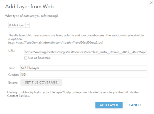
Adding an XYZ tile layer to ArcGIS Online is very similar to adding OGC services. In the Map Viewer, choose the Add layers from web option. Next, select Tile Layer from the list of options. It is important to correctly enter the URL in the same format as the example above, otherwise the layer will not be visualized.
Additionally, you have the option to select a title and to add credits for the layer. It is possible to set the extent that needs to be visualised and to add the layer directly as base map. Once the layer is added to your map, you can save it in ArcGIS Online. This makes the map also available for use in ArcMap and ArcGIS Pro.

Add XYZ Tile Layer to ArcGIS Pro
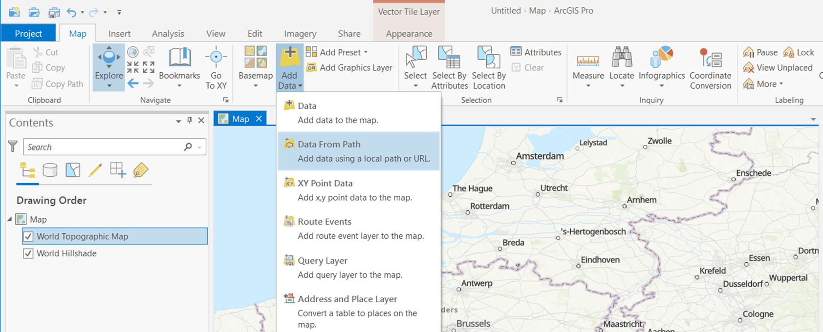
There also exist a method to add the XYZ tile layer directly to ArcGIS Pro. This function is only available from version 2.6 onwards. For this, you open a new map in ArcGIS Pro and select the option Add data from Path. The URL of the XYZ tile layer can be added, while taking into account that the format should be similar to the example above. It will be added as a layer to the map, and you could even convert it to the base map.

Additional information
Adding XYZ tile layers to the ArcGIS platform:
- https://doc.arcgis.com/en/arcgis-online/create-maps/add-layers.htm#
- https://pro.arcgis.com/en/pro-app/latest/help/mapping/layer-properties/add-layers-to-a-map.htm
- https://community.esri.com/t5/arcgis-pro-ideas/add-xyz-tiles-layer-tms/idi-p/940481
Historical maps of Belgium as XYZ Tile Layers on the NGI website:
Tile layers ArcGIS software:
3 ways to contact the Esri BeLux Support Team
Click here to fill in our Support Form

